City Wide Comprehensive Plan Approved by Council
September 25, 2024
Planning Bedford’s way to the future, City Council Tuesday adopted its new Comprehensive Plan which, according to the meeting agenda, “outlines goals and objectives used to guide future growth and re-development” for the City.
According to Bedford’s Director of Development Wes Morrison, the objective for the Comprehensive Plan is to “make the Bedford market competitive, [to] create common ground and provide a guide for making [planning] decisions.” The previous Plan, the meeting agenda stated, “was adopted in 2001 and updated in 2010.”
Leading up to the Tuesday’s approval, the agenda indicated the Council and Planning and Zoning Commission had held five joint public meetings to review the Plan with its “proposed special districts and the future land use map.” The agenda stated that Planning and Zoning also held six meetings of its own to discuss “specific components of the Plan.”
Riding on a recommendation from Planning and Zoning, the Council voted unanimously (6-0) to accept the Comprehensive Plan with two controversial land use modifications.
Meadow Park Development
The modifications, centered on the undeveloped land at Meadow Park that are owned by the Hurst-Euless-Bedford-Independent School District (HEB ISD), are an apparent attempt by Council to balance residents’ pleas to preserve “green space” with anticipated requests of potential developers for higher dwelling density.
The property covers approximately 57 acres mostly with gently rolling hills covered with grass and trees. This includes Bedford’s Bark Park and a segment of the Linear Trails, plus a couple of baseball fields and two youth soccer fields that make up the Meadow Park Athletic Complex.
Originally, HEB ISD bought Meadow Park with the intention of building a third high school.
The first modification, as described by the agenda, is a change in the name of the land use classification from “Lifestyle Residential” to “Neighborhood Village.” The second is an adjustment of the classification’s density that evolved from 10 to 20 dwelling units per acre down to a density of three to 10 units. The provisions for “live-work/home-based occupations and Accessory Dwelling Units” have also been eliminated.
This classification adds “some flexibility,” explained City Manager Andrea Roy at an August 27 special joint session of City Council and the Planning and Zoning Commission. For example, she said, by preserving some of the trees, a developer could increase dwelling density in another part of the property and, overall, be encouraged to “do something different and unique” rather than lay out a typical grid pattern.
According to City of Bedford records, Meadow Park is zoned with an R-15 designation, which permits single-family residential homes on lots of at least 15,000 square feet. That would equal about a third of an acre for each lot.
Jean Freeman, a co-organizer of the Meadow Park Action Committee, commented after the Council meeting that she was “pleased” with the reduction of the Plan’s dwelling density. “To me, that was a big win,” she said. However, with a long path ahead before a developer even buys the property, there are clearly lingering concerns of which she addressed the Council.
“The current tree ordinance,” Freeman conveyed to the Council and City Staff, “does not have a strong enough bite to encourage developers to protect our existing trees that add beauty and value to our community.” She said that she and the neighbors she represents are looking for assurances that “natural surroundings will be protected” and that the Council, referring to them as “our frontline,” will not “cater to developers.”
“The neighbors”, Freeman emphasized, “are genuinely concerned about losing accessible green space, traffic congestion and, understandably, the impact of their property values” with the prospect of a higher density development. She added that “somewhere,” as “a shared community” with the School District “there is a middle ground” for compromise. “The School District holds the deed,” she concluded, “but City Council controls the zoning.”
“We have to wait and see what a developer is going to bring,” Mayor Dan Cogan cautioned, responding to Freeman’s comments. “As you said,” agreeing with her in his response, “we are the last line of defense here and we take that responsibility very seriously.” Repeating a comment he made in a previous Council meeting, Cogan said the HEB ISD superintendent had indicated to him that the District wants to see homes on in Meadow Park in the $800,000 to $1 million price range. “That would only enhance property values,” Cogan stressed.
The “Neighborhood Village” land use classification, Cogan continued, is to be applied to Meadow Park to specifically encourage developers to be creative in designing the layout. He said the revised classification would potentially provide a mix of housing types and help protect some of the green space. He also echoed City Manager Roy by saying it would discourage the use of a standard grid pattern with nothing but rows of houses.
In addition, Cogan said, “there are so many old trees on that property that I want to try to preserve as much as possible.”
Three “Distinct and Different” Overlay Districts
The Comprehensive Plan primarily targets three “distinct and different” overlay districts for redevelopment into “unique and interesting places” that “don’t exist today,” as presented by Tony Allender at the August 27 joint session. Allender is an urban planning and economic development principal at Hawes Hill and Associates, which was contracted as a consulting firm by the City to help develop the Plan.
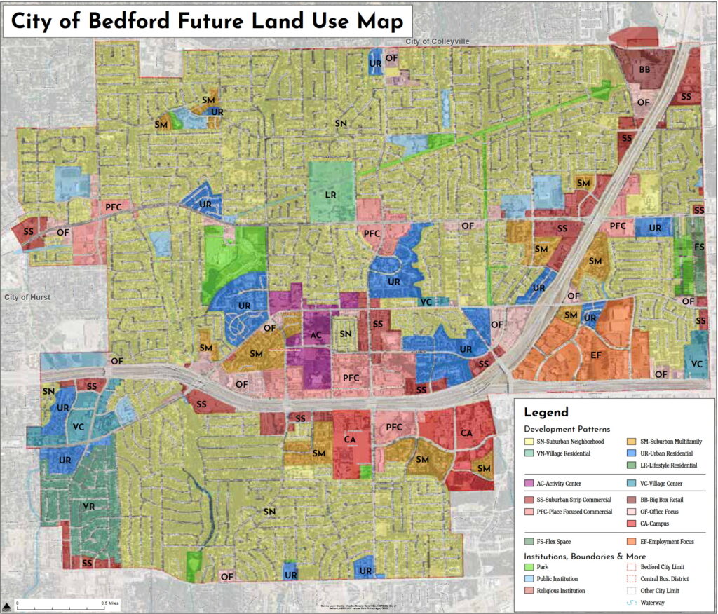
There are 14 land use classifications, Allender explained which are used as building blocks to redevelop the districts as well as other targeted areas of the City.
He said the land use classifications “talk to the character of an area,” while in contrast, zoning codes are “the law” applied toward development.
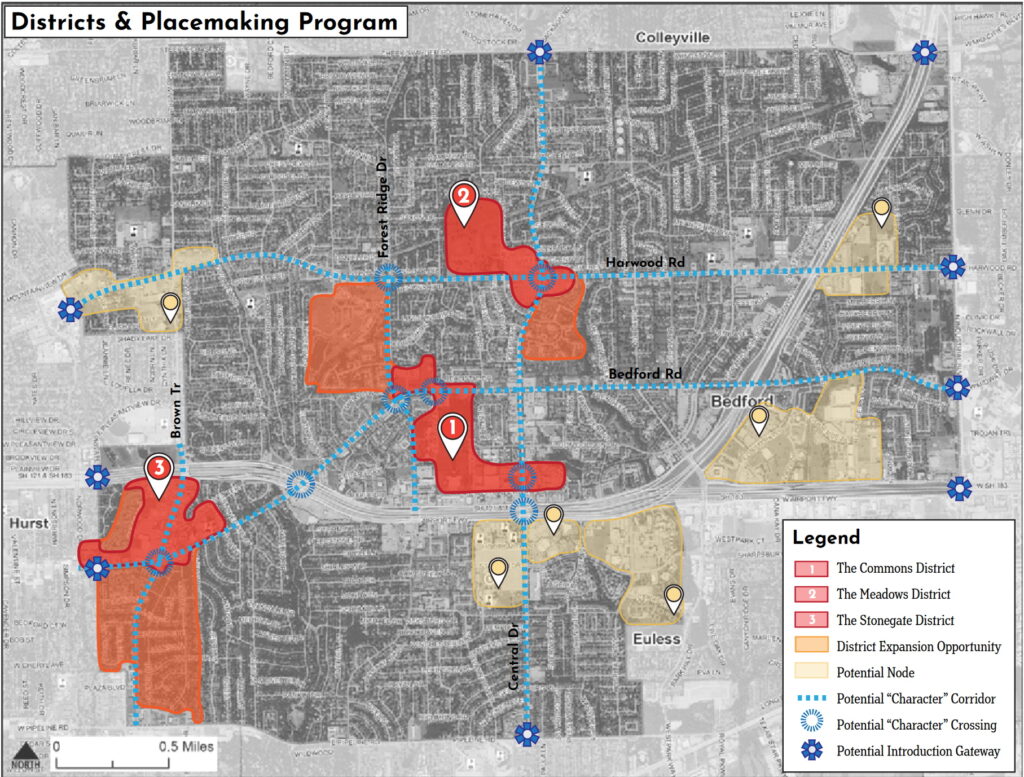
The Plan’s three special districts, are labeled as “The Commons District, the Meadows District and the Stonegate District, Allender further explained. A couple of the key objectives, he outlined, would be to transition “strip commercial development” into “places that are more destination-oriented” and focus on converting some strategically placed multi-family apartment complexes into “urban residential” units, such as townhomes.

Meadow Park, Bedford Journal Project photo
City of Bedford Future Land Use Map, courtesy of City of Bedford. Click on map for enlarged view.
Bedford Map of new special districts, courtesy of City of Bedford. Click on Map for enlarged view.
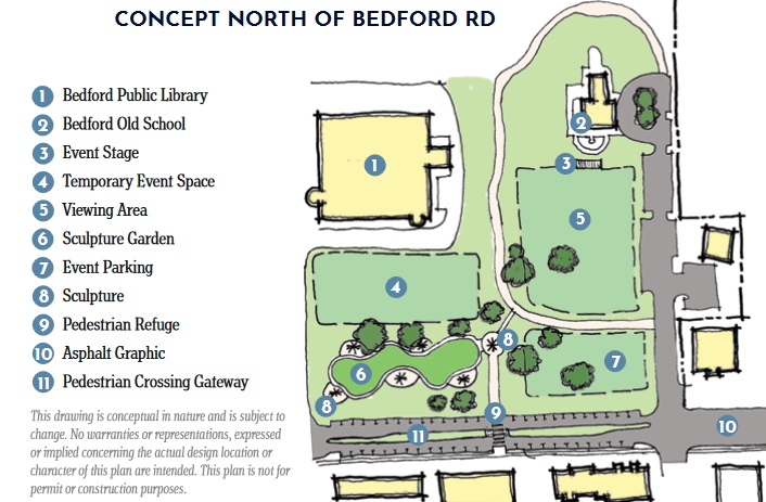
Conceptual draft of the proposed Commons District north of Bedford Road courtesy of the City of Bedford
The Commons District
The Commons District,” centered on the undeveloped acreage referred to as Bedford Commons, includes the area occupied by City Hall and links across Bedford Road to The Old Bedford School, the Bedford Public Library and north to Generations Park.
Allender stated that Bedford Commons would pivot away from apartments and add “event streets,” which could be closed off “so events can spill out into the open spaces.”
The planning of the proposed Commons District, is further ahead of the other two districts as the City has signed a Memorandum of Understanding with Midway Development to research viable options for a Bedford Commons concept. According to an update from Mayor Dan Cogan, a presentation from Midway is anticipated sometime in the first quarter of 2025.
In general, for the areas around all three districts, Allender presented concepts on connecting new amenities, such as open spaces, plazas, lawns, parks, trails and public art that would add to the “attractiveness and interest” of the area. It would create new spaces for people to “gather and hang out.” He emphasized there would also be an option for improving existing parks and adding trees and green spaces where it makes sense to create a “lush” environment.
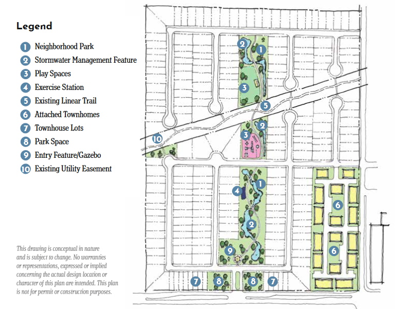
Conceptual draft of a Meadow Park development as part of the proposed Meadows District courtesy of the City of Bedford
The Meadows District
Along with featuring a range of housing units, as already detailed above, the Meadows District “builds on the 57 acres owned by the school district,” Allender explained. The Meadows District, he said, would include the “Kroger” and “Big Lots” shopping centers as retail components.
He also discussed “mobility adaptations,” which are methods of adjusting road and lane width, as well as using landscaping to help regulate traffic speed through the proposed districts.
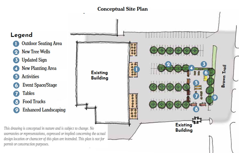
Conceptual draft of the proposed Stonegate District courtesy of the City of Bedford
The Stonegate District
The objective of the third district, the Stonegate District, Allender stated, would be to redevelop the corridor along Brown Trail, south of Airport Freeway, into something “that is fun and funky and cool.”
The concept for Stonegate, he said, is to experiment with new ideas, such as “a mix of housing” and to create a space where new and unique businesses can grow. It would include “character corridors and crossings” for pedestrian and bicycle “connectivity.” The district would be centered on a zone for experimental ventures and a space for artists, he added.
No time to follow news developments in the Bedford Journal Project?
The Project introduces a free email newsletter with its feature articles delivered to your inbox at the end of each month.
Visit the ‘About’ page to read more and sign up!

